The latter end of the ebb and a backing forecast - what better way to make the most of the November sunshine than to spend an afternoon exploring the Shambles! I find the topography of the bank fascinating, with its strange tentacular shape caused by the regular ebb and flow of the tide over it.
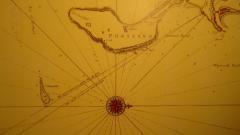
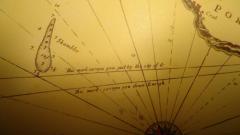
My aim was to explore the use of landmarks as shown on the detail photos of the chart of Weymouth bay which dates from the late 17th century; the chart is dedicated to Captain George St. Lo, who became a captain in 1682, was captured by the French in 1690, and after retirement from active service was, among other responsibilities, appointed to guard the workforce building the Eddystone lighthouse.
Owing to the breakwater it is no longer possible to use Sandsfoot Castle as the chart indicates, but Wyke church, also shown, is almost as good, and visible over any shipping in Portland harbour as well.
The chart shows two bearings, the lower of which is roughly equivalent to Wyke church just clear of the headland on Portland. I experimented by crossing the bank at low tide at various places between half a mile and a mile from the East Shambles cardinal, and found that the bearings are quite good; crossing the bank with Wyke church open of the headland gave about 10m depth at low tide, as compared with 6m a few hundred yards to the west.
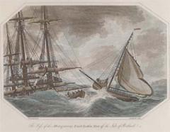
I think the bank may have moved a bit since the chart was drawn - which may help to explain how the pilot of the 'Earl of Abergavenny' (draught about 6m) mistook his position in 1805, with the result that the ship (captain John Wordsworth, brother of the poet) struck the east end of the bank, and then sank in the middle of the bay, with survivors clinging to her masts and rigging, which protruded from the water even when she was on the bottom - a masterly attempt on the captain's part to get far enough inshore for at least some lives to be saved.
When asked by the captain, 'Are your marks open?' the pilot replied 'Aye aye, sir' though in the fading light of a cold February afternoon in a strong ebb it must have been difficult for him to judge how much easting was necessary; when you look from the Shambles, the hills behind Abbotsbury make it difficult to see even the church through binoculars.
The chart, then, is, even after more than three centuries, of use - but with care! If anyone is interested in obtaining a copy of the chart, for historical rather than navigational purposes, do contact me.
A full account of the wreck is available at http://www.weymouthdiving.co.uk/cd_rom.htm
Steve Fraser
Submitted on 23rd November 2011


